

In Lao PDR, there are three large casinos presently in operation: the Savan Vegas Hotel and Casino, the Kings Roman Casino and the Dansavanh Nam Ngum Resort. They are facing controversies over forced evictions, dispossession of farmlands belonging to the local rural communities, and are ridden with mafia-style armed fights among rival casino and investor factions. In January 2005, China’s anti-gambling campaign forced many casinos and small gambling houses to move to countries on China’s southwestern border including Myanmar, Laos, and Vietnam. Meanwhile, Lao officials and others, including middlemen and land developers, are reaping the cash benefits from this so-called rural development.
“The damned Chinese are taking over Laos,” the words spat out of a farmer whose nickname is Khoua living in the northern province of Luang Nam Tha. He was mouthing what most Lao people believe. Rural people dispossessed of land, urban dwellers witnessing the slow demise of their once elegant cities, all blame the mainland Chinese. Their presence is increasingly obvious, whether it be in the high speed motorcades blasting though Luang Prabang or in the proliferation of Chinese enterprises and their gargantuan construction projects, many of which lie echoingly empty and idle after completion. The influx of Chinese workers is affecting the local people’s chances of employment or skills training. But in the midst of frustration about the Chinese presence, what often goes unremarked or largely forgotten is that the Chinese are there as a direct result of the investment policies of the Government of Lao PDR, with many benefits from power to wealth being reaped by a long line of Lao officialdom.
When the author visited the area in November 2012, there were massive boards advertising the latest megaproject. Some provinces like Oudomxai north of the capital are more Chinese than Lao. That being said migrations and state borders have shape-shifted over the centuries blurring ethnicities and cultural loyalties. But what is obvious is the anger and resentment aimed at China while at the same time failing to recognise the agency and responsibility of the Lao government in ceding land and concessionary deals in return for investment and bribes.
This development complexity is best exemplified in the huge (and often bizarrely designed) casinos and gambling establishments that are expanding under the same perseverating rhetoric of development and poverty alleviation by which large dams and roads are being built. While these casinos have been written about in the mainstream media, very little analysis has been done about what they mean for rural people and their livelihoods.

Ferries bringing patrons across from Thailand and China for gambling (Photo by Melinda Boh.)
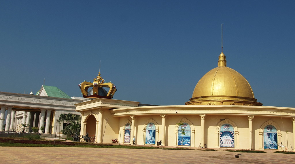
From Chiang Saen in Thailand’s north, the white colonnaded building across the river, topped with a huge gilt crown is a bizarre sight. From Huay Xai in Laos, a potholed road through farmlands leads to the casino complex. The car suddenly jolt-lands on to thick cement, marking the casino’s boundary in Dork Ngoui Kham. Half an hour later we spot the golden cupola, its clock set on Beijing time, marking Bokeo Province’s Special Economic Zone (SEZ) office.
The nearby King Roman casino reveals plaster toga-clad statues alongside Chinese patriarchs and the symbols of the newest local religion: gambling. Parked nearby were two stretch limousines. Inside the building, men in suits gambled at the tables. “Kunming officials doing a site inspection,” was the official story from an attendant.
The only Lao person we saw was a farmer on a dust-covered motorbike with his equally dust-covered wife, narrowly avoiding being pushed into the Mekong River by the boat passengers.
The concession area includes archaeological treasures, importantly the ruins of a 16th century city reputedly built by King Setthatirat. Other remnants, possibly from the Mon empires of the first millennium CE, are considered to be of World Heritage value. Instead they may end up under the runway of an international airport planned to bring patrons in, but fiercely resisted by the local farmers. History will be replaced by what appears to be a gambling based narco-empire, where anything goes. For Laos, it means that some of the most fertile arable land and considerable archaeological treasures would soon be buried under asphalt to feed the gambling industry.
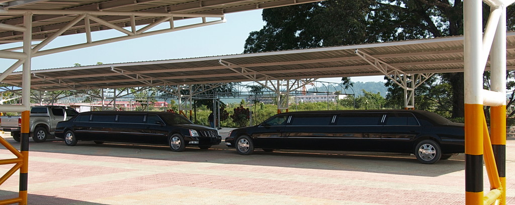
Stretch limousines pick up selected high rollers from the airport (Photo by Melinda Boh.)
Civilising
Defending the casino and entertainment complex, a senior Chinese manager told researcher Pal Nyriri: “Before it was opium and drug businesses. There were no roads, no electricity … Laos is developing and it [the casino] is good for them.”
Zhang Wei, the casino’s principal developer, told Thai sociologist Pinkaew Laungaramsri of Chiang Mai University: “The biggest obstacle is that villagers … do not understand us. We have rented all the land and forest … but they … cut … or burn them. We can’t go around, arresting or beat up (sic) and fine the villagers who burn our gardens … it will cause ethnic issues.”
A local NGO worker, requesting anonymity, recalled taking a Chinese delegation to the site in 2009. “The three Government officials, a journalist, an environmentalist and a few academics were shocked at what they saw. ‘This gives China a bad image,’ they said. When we stopped; a crowd of up to 70 to 100 village people assembled shouting that they would not give up their land. The area is one of the most fertile and productive in Laos.”
They pointed to a white Humvee. “That’s the local official. Zhang gave him and the (Lao) police the same cars.”
China may see itself as a civilising influence, drawing on its long and remarkable history, using its wealth and dynamism to bring rapid economic growth. But with its entrepreneurs building casinos like those at the Lao border, China risks reinforcing its growing reputation for exploiting its neighbours.
Because although it’s the Lao government’s party apparatchiks and provincial officials whose signatures and rubber stamps bless these casino developments, it’s China that gets the bad press, a point clearly understood by the visiting Chinese delegation. The development of ‘legal/ illegal’ states through the formation of SEZ’s has enabled the Lao government to consolidate power, and amass wealth, patronage and control, while portraying itself as a helpless lackey of China.
Laos is fast gaining a reputation as a lawless state. It has shown unwillingness to arrestwildlife trafficker Vixay Keosavang while it faces continuing criticism for its intransigence in not being serious about investigating the high-profile disappearance of Magsaysay award winner Sombath Somphone. Moreover, Laos continues to face allegations of human rights violations, money laundering and profligate illegal logging that are causing both international concern to its many foreign donors and local frustration.

The so called “red carpet”, the road being paved pink for the patrons (Photo by Melinda Boh.)
SEZs and other confusions
The casinos in the SEZ epitomise the complexity of the modernist zeal with which the Government of Lao and China pursue investment. Observers like Danielle Tan have noted the SEZs bring a post-socialist neo-liberal model to the Lao-China border zones. For nations that expound socialism and wisdom of central control, this is a strange choice. Neo-liberalism increases state income through taxes, exploits labour and expropriates land from traditional owners and farmers. The renowned sociologist Pierre Bourdieu considers neoliberalism “a program for destroying collective structures”, and even nations themselves.
With their confused legal frameworks and ambiguous status, SEZs invites all sorts of temptations. The implicit freedom tempts the seamier side of legitimate trade and investment particularly in the fabled Golden Triangle. Added to this mix, the Chinese fascination with gambling and luck makes Bokeo’s proximity all too tempting.
Along with disappointed losers, Tan found evidence of drug sales and money laundering, while Li Quan a London based tiger conservationist, told the Global Times that Lao casinos were trading posts for endangered species. Others are worried about child trafficking, rape and tax farming 1.
Tan alleges that the former military junta and drug lord Lin Mingxian is a major investor in the King Roman Casino, a charge denied by Zhang Wei. Ying and Zhang, of China’s Institute of Contemporary International Relations (CIR) and part of the 2009 delegation, agreed, writing, “While the nominal boss of the Casino in Bokeo is a Fujian native with a Hong Kong passport, it is … likely… the real investor is a drug cartel from Myanmar.”
The other side of China’s double jeopardy is legitimacy. The Bokeo casino is a photocopy of those in Mong La (Myanmar) and Boten (Laos) both managed by Zhang Wei, and both closed by China after evidence of mafia-style gunfights and crimes. However the King Roman is within Lao sovereign territory, while the others were on international no man’s land.
The Vice Prime Minister of the Government of Lao PDR, Somsavat Lengsavad, reacted to China’s concern about ongoing casino development with assurances that no further concessions would be granted as “casinos were a bad model for Laos.” But barely six months later in March 2014, the Vientiane Times announced plans for another casino in the South.
In total forty-nine SEZs are planned. How many will have casinos is anyone’s guess, and pose a serious concern to China.
Size matters
The CIR’s critical appraisal of Laos’ transparency backs Nyiri’s research revealing that the Government of Lao granted the Hong Kong registered King Roman group a concession for the Bokeo land in 2007, after a down payment of US$850,000.
Lao government media KPL reported 827 hectares were ceded for 40 years; the maximum allowed under Lao law, but at variance to the company’s own estimation of 10,300 hectares for 99 years. In 2010, Zhao reported the new casinos would be bigger in scale than those in Boten, bragging that US$500 million would be spent developing the site, more than ten times the Laos national health budget.
A resident of Huay Xai who declined to be identified, admitted the casino is run down: “The paint’s peeling and shops boarded up. Less people visit now. One rich guy hired some [Lao] cops to protect him, but they shot him and took his money. Despite joint patrols, we still have shootings, as the Chinese mafia are using the place as a staging post. Gamblers are afraid. As for the organic farms and markets they promised, well who would buy the stuff? The farmers who lost their land are now broke and they used to produce what the casino promised but never delivered.”
“The casino’s still trying for the airport, but there is well-organised resistance. The locals called in Thai TV. The Lao police arrested two cameramen and held them for two weeks. The Thai government responded by closing the border until they were released. Now it’s a stand-off. The PR risk is too high.”
China has its own problems with crime. What it does to curb the influence of its neighbour will be interesting to see.
Post script: In late 2013, the Lao media announced that the farmers had been given their promised settlement. The casino had agreed to pay a compensation amount that was found satisfactory to the government. Many on the Lao agribusiness list-serv cheered.
Following up on this story, I was told by the above long term resident of the area (new laws in Laos restricting critical media make me reluctant to name anyone for fear of recrimination) that the company had in fact offered compensation way over the odds as the farmers had been both successful in gaining publicity and in holding out, fearing the same poverty that had mired their neighbours.
But the informant said the Lao government refused to give their imprimateur to the negotiated rate fearing that the amount offered would set an unhealthy precedent for other areas of Laos, so the farmers were given a significantly reduced amount. Hence the term “found satisfactory to the government” does not mean what one might have assumed.
This article was written by Melinda Boh for the Mekong Commons website and published here on 1/31/15. It is reposted in its entirety with permission from Mekong Commons and the author. ExSE is excited to begin a new cooperative partnership with the Mekong Commons team in sharing analysis and reporting.


